Issues and Residents Concerns are:
Filey Town Flood Investigation Report, Filey Town Council and The North East Yorkshire Strategic Flood Risk Assessment (SFRA) report recommends NO new development take place in areas at risk of flooding, until alleviatory measures are in place.
Residents are in favour of the Filey Flood Alleviation Scheme.
They are NOT in favour of a Proposed New Housing/Residential Development in a Flood Management Zone.
As supported in the NPPF Policies and SFRA report.
Why do SBC officers repeatedly contradicted themselves? it is plain to see why they classify the area as a flood zone 3 in the
Strategic Housing and Employment Land Availability Assessment (SHELAA).
The Environmental Agency classify flood zones as:
Flood Risk Zone 1 - Low Probability - 1 in 1000 year = 0.1% chance of flooding.
Flood Risk Zone 2 - Medium Probability - 1 in 100 year = 1.0% chance of flooding.
Flood Risk Zone 3a - High Probability - Greater than 1 in 100 year - 1.0% chance or greater of flooding.
Flood Risk Zone 3b - Functional Floodplain.
The evidence supports a classification of Flood Zone 3 as the area flooded in 2002 and 2007?
Greater than 1 in 100 year chance of flooding.1.0% chance or greater.
The Environment Agency classify the area as a Flood Zone 1,in comparison it appears so inconsistent to SFRA and SHELAA.
Storm water ran off site HA23 now HA24 into properties on Church Cliff Farm, residents witnessed this catastrophe.
Twice in a 5 year period that surely qualifies the area a flood zone 3a .as recognised by the SHELAA working group.
However the answer is NO, SBC do not recognise this now.
Note: Since this SHELAA report there have been NO material changes to the area.
The Filey Flood Alleviation Scheme Plan by SBC Plan Number 15/02657/RG3 has been granted and passed .
The decision notice full planning permission dated 21st March 2016 .
(Please note site HA23 now HA24 is within this plan area, this formally qualifies the area to be a flood management zone).
SBC Local Plan, Examination in Public was July - Oct 2016.
SBC Local Plan was Adopted on 3rd July 2017.
This period from the FFAS Plans passed 21st March 2016 to 3rd July 2017 Adopted Local Plan is 1 year and 4 months.
At NO stage in this period did SBC recognise site HA23 now HA24 as a flood management zone within the Local Plan Methodology and Assessment
This breaches current central government policies within the NPPF , PPG and SFRA.
That are made to protect such vulnerable flood risk areas.
One can only presume this critical omission was to avoid the site being rejected at an early stage of the assessment process.
HOWEVER:
The issue is if later development is granted it will not ease flooding issues on Site HA23 now HA24.
The reasons why are:
Inadequate Surface water drains and Sewer system
Critical Drainage Area
Critical Ground water and surface/storm water runoff area
Sensitive to Climate Change
Church Cliff Ravine - Flood Zone 3 - Culvert drain capacity issues
Waste Water Treatment Works- Capacity issues
Residential internal and external flooding.
Flooding and Pollution
Flood Zone (site HA24 High Risk of Flooding)
The Housing Land Selection Methodology Assessment (HLSMA) Site Assessment paper states at Stage A.
HLSMA - Question number 4 -
"Does the site lie within an area considered to be unsuitable due to its position within a flood risk zone ( high risk)?"
SBC answer to this question is NO.
If land is Flood Zone 3b ,it should be dismissed at that point.
However: SBC don't recognise this identification of a flood zone 3 recorded in its supporting documentation. They state it is a flood zone1 and also don't recognise the identified critical drainage area and critical Ground water/Storm water run off area and reported sewer flooding. Recorded in its supporting documentation.
HLSMA - Question 16 - Flood Risk - in the HLSMA site assessment paper
Assessment comments = Flood Zone 1
But the assessment paper fails to mention the area is also identified as a critical drainage area, critical groundwater and surface water run off area, identified as a sewer flooding area and sensitive to climate change, again recorded in its supporting documentation.
SBC state that they are not formally recognised however they are part of the National Planning Policy Framework (NPPF), National Planning Policy Guidance (NPPG) and Strategic Flood Risk Assessment (SFRA) for this area.
SBC have a legal obligation to follow these policies.
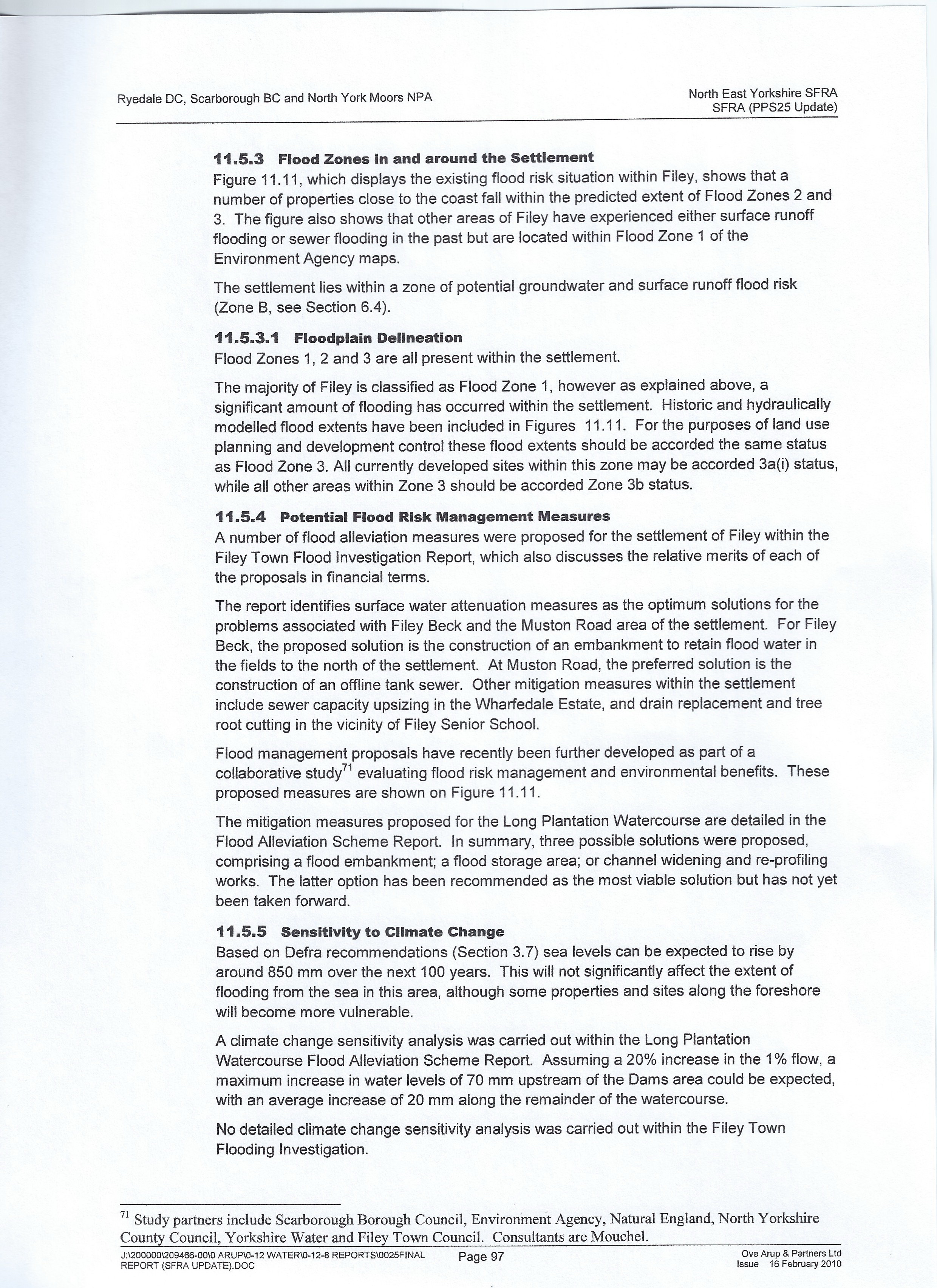
The Strategic Flood Risk Assessment (SFRA) States in section 11.5.3.1.Floodplain Delineation.
"for the purposes of land use planning and development control these flood extents should be accorded the same status as Flood Zone 3. All developed sites(ie: Wooldale Drive/ Church Cliff Farm) within this zone may be accorded 3a(1) status,
while all other areas(ie: outside of development limits Site HA23) within zone 3 should be accorded Zone 3b."
see section 11.5 Filey, 11.5 to 11.5.8 SFRA Report it is lower down this page.
yet another example of specialists independent reports commissioned by the Authorities not followed in the land assessment.
See full SFRA report in SBC examination in public library. (document number CSD27). accessible on scarborough.gov.uk website.
PLEASE NOTE:
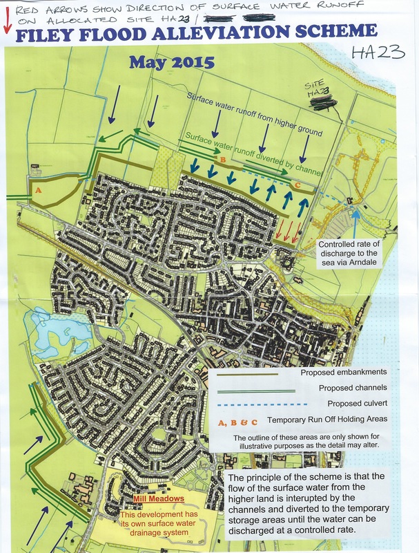
When the Filey Flood Alleviation Scheme has been completed on the North side of town, the storm water run off will run away to Arndale Ravine ( Country Park/Yatch Club).
However this will NOT be the case with development on Site HA23 as the topography of the land slopes in the opposite direction down toward Filey, Wooldale Drive east side and Church Cliff Drive , Church Cliff Farm Complex.
If a development drainage system connects to the existing drains and sewer system this will flow down Church Cliff Ravine classed as a Flood Zone 3, Critical Drainage area, Critical Ground Water and Surface/Storm Water Runoff Zone as stated in the SFRA report and Environment Agency.
Church Cliff Ravine Storm water drain covers frequently blow off the culvert drain due to heavy rain fall.
Residents on the Parishes Estate and Church Cliff Farm have concerns over drain capacity in the area with storm water overloading the drain and sewer system and resulting in residential flooding.
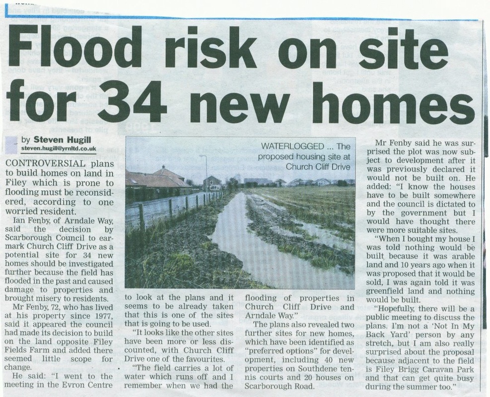
Evidence of this is shown in the Filey Town Investigation Report, Atkins 2004, Drawing 5002531/WAF017.Plus supporting pictures, News paper article, The drainage system here has already surpassed its finite limit.
The Filey Flood Alleviation Scheme money has already been granted by central government and regional flood funding bodies,
planning has been passed for works to commence.( work was scheduled to start March 2017 , but is now on HOLD WHY?)
The residents of Filey around the site of HA23 (now HA24) see no extra benefit of development in this area as everything is already in place for flood defences to protect Church Cliff Farm properties without residential development.
Residents want the original Filey Flood Alleviation Plan, SBC Plan 15/02657/RG3. Drawing number PB1154/9005 to be constructed in this area, as this already planned Flood Alleviation will be above ground.
The benefit of this design is easy maintenance and if any flaw in design was to appear it will be easier and more cost effective to rectify. unlike an underground system.
The only benefits residents can see with a residential development on this site are:
The benefit of gain of profit for the Landowners.
The benefit of gain of profit for the Developers.
The benefit for Scarborough Borough Council to offload the responsibility and a section of the construction cost of the Filey Flood Alleviation Scheme.
( Please note this will also include site HA22 (now HA23) from Parish Wood to Scarborough Road, a considerable area of the Filey Flood Alleviation Scheme )
Therefore , SBC gains the difference from the 5.5 million Filey Flood Alleviation Scheme project that has already been granted and given by central government and the regional flood funding bodies.
It now becomes clear to residents why SBC have pursued this controversial site for Housing Allocation .
If Methodology and assessment. Policies and Protocols are not followed correctly in the process
then serious questions about legal compliance are raised.
Residents feel that through this whole assessment process there has been a lack of integrity and honesty.
As highlighted on this website there are serious questions about omissions of critical documents, policies and information in the assessment of site HA23 (now HA24)
Residents continue to question abuses of power, manipulation and unethical conduct by persons entrusted with positions of authority.
Download Files on this page refer to the issues of Flood Risk ,
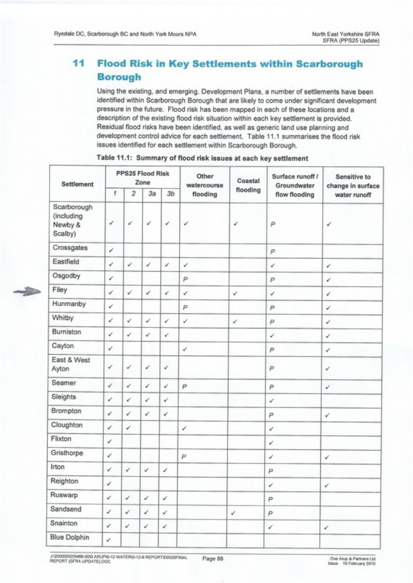
The Northeast Yorkshire Strategic Flood Risk Assessment , Update 2010 (SFRA) results.
Show Filey area HA23 to be a Flood Zone 3b, Groundwater and surface water(storm water) runoff zone, Critical drainage area and sensitive to change in surface water (climate change) all identified in the SFRA, ( Download Files @ bottom of Page)
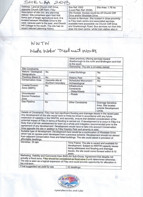
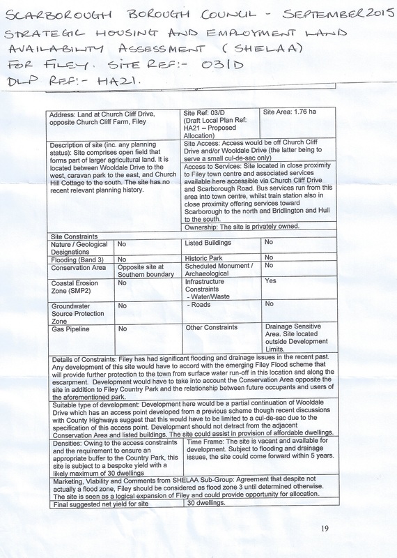
The Scarborough Borough Council Strategic Housing And Employment Land Availability Assessment 2013 and 2015 (SHELAA).
State the area to be Flood Zone 3.There have been NO material changes to the area since the reports.
The Filey Town Flood Investigation Report(Atkins 2004) map 5002531/WA/F017.
Shows instances of internal and external Flooding to properties in the HA23 surrounding areas.
The Statement of Michael John Cockerill on Behalf of The Local Planning Authority , Edited version .
( ref: Mill Meadows Estate - what a disaster that's turned out to be!)
This report also states the area to be Flood Zone 3, Ref: SFRA Report.
This report has relevant information specific to Wooldale Drive, Arndale Way, Church Cliff Drive and Site HA23.
The Northeast Yorkshire Strategic Flood Risk Assessment , Update 2010 (SFRA) results.
Show Filey area HA23 to be a Flood Zone 3b, Groundwater and surface water(storm water) runoff zone, Critical drainage area and sensitive to change in surface water (climate change) all identified in the SFRA, ( Download Files @ bottom of Page)
The Scarborough Borough Council Strategic Housing And Employment Land Availability Assessment 2013 and 2015 (SHELAA).
State the area to be Flood Zone 3.There have been NO material changes to the area since the reports.
The Filey Town Flood Investigation Report(Atkins 2004) map 5002531/WA/F017.
Shows instances of internal and external Flooding to properties in the HA23 surrounding areas.
The Statement of Michael John Cockerill on Behalf of The Local Planning Authority , Edited version .
( ref: Mill Meadows Estate - what a disaster that's turned out to be!)
This report also states the area to be Flood Zone 3, Ref: SFRA Report.
This report has relevant information specific to Wooldale Drive, Arndale Way, Church Cliff Drive and Site HA23.
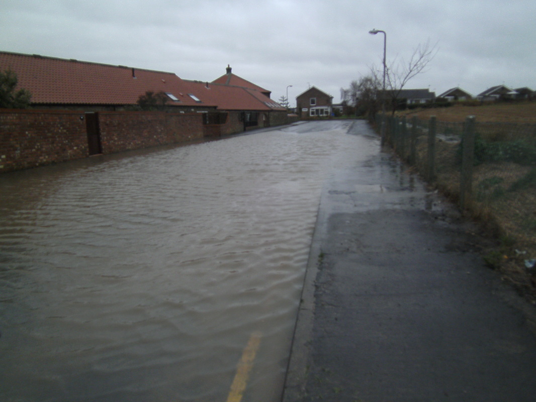
Church Cliff Drive 2012/11/25
|
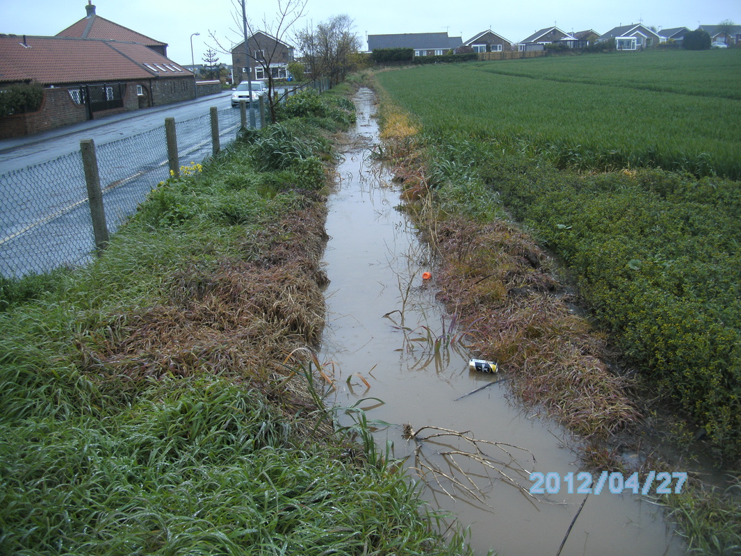
2012/04/27
|
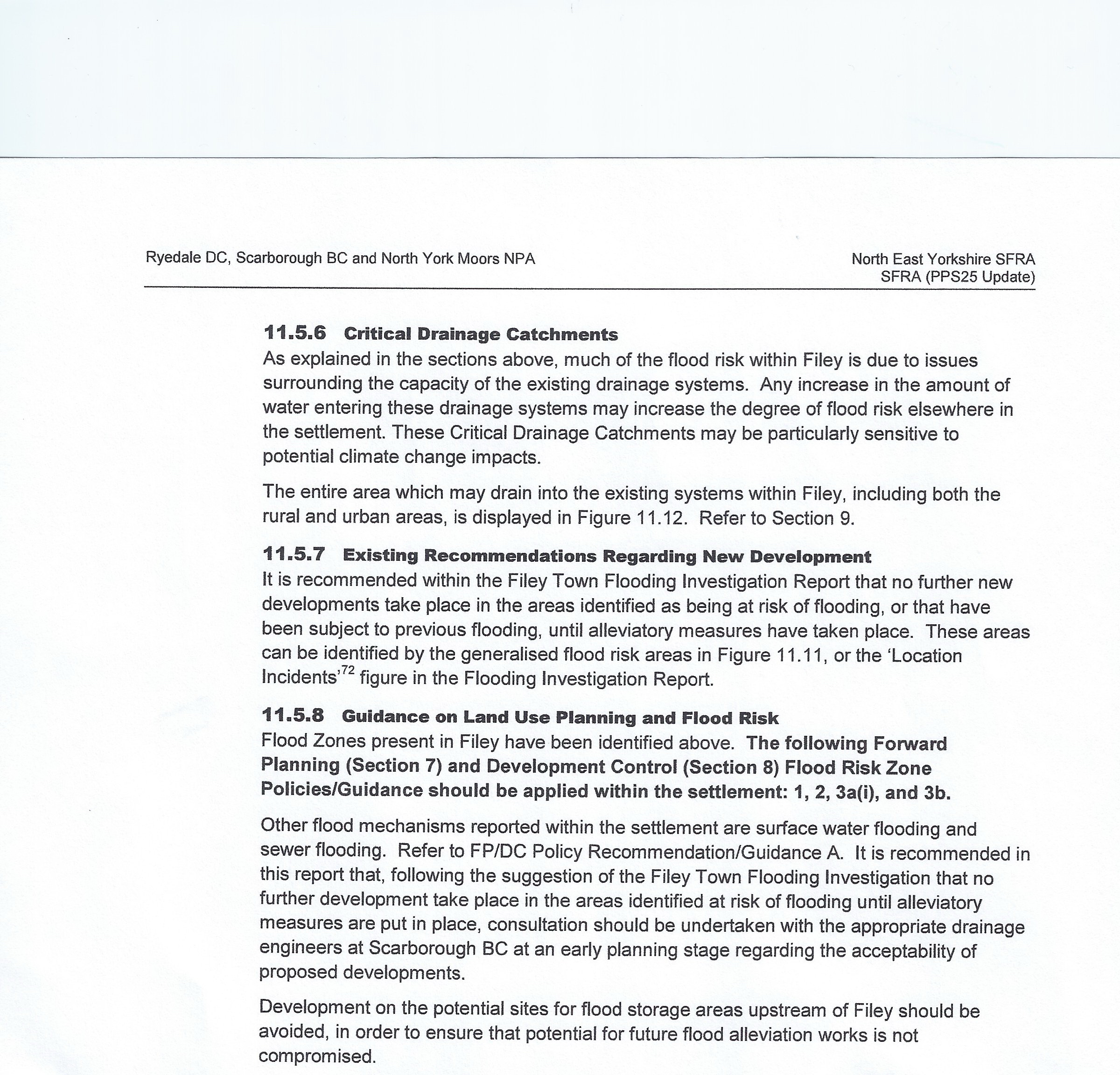
The Filey Section of the Strategic Flood Risk Assessment Report, SFRA
|
Strategic Flood Risk Assessment , North East Yorkshire.
Edited 3 page version specific to Filey. 11.5.1 to 11.5.8 as above. | ||||||
Strategic Housing and Employment Land Availability Assessment (SHELAA)
The 2013 and 2015 Versions.
Both SHELAA Reports show in the Site Constraints ,
Question is the site in Flooding (Band 3) Answer NO. - But the foot note contradicts this by stating the site is a flood zone 3.
As identified by the North East Yorkshire Strategic Flood Risk Assessment (SFRA)
Therefore in breach of the National Planning Policy Framework 100-103 and Planning Practice Guidance set to protect such areas.
|
|
|
Strategic Housing and Employment Land Availability Assessments Full report 131 pages , September 2015
| ||
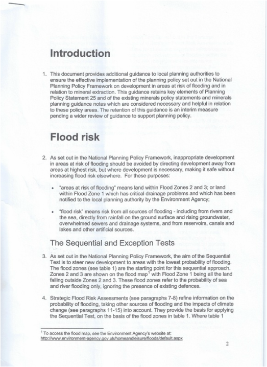
Left is a copy of the first page of the National Planning Policy Framework Technical Guidance Notes . Specific to Flood Risk areas .
Note 2. Flood Risk the definition of
"areas at risk of flooding" and "flood risk"
Site HA23 meets both definitions.
evidence shows this site to be flood zone 3, and or flood zone 1 and identified with critical drainage problems and ground water/surface water run off issues.
Note 3. The Sequential and Exception Tests
States to steer new development to areas with lowest probability of flooding.
Development is not necessary and can be sited in an alternative less vulnerable site in Filey
see examination in public - Matter 2
The Full Technical Guidance can be Downloaded from the last page,
Local Plan Policies - National Planning Policy Framework ref: Technical Guidance. NPPG.
|
Edited version items 7 -27 highlighting the drainage and sewer issues around Site HA23, Wooldale Drive, Arndale Way, Fir Tree Drive and Church Cliff Drive
| ||
Click on files below to see full reports and maps with the issues that currently affect Filey and Site HA23
|
Strategic Flood Risk Assessment Map , Groundwater and Surface water runoff zones. Includes Filey Site HA23 and surrounding area.
| ||
|
Strategic Flood Risk Assessment Map, Critical drainage areas,
Includes Filey Site HA23 and surrounding area. | ||
|
Strategic Flood Risk Assessment Map, reported Surface runoff flooding and reported sewer flooding , Filey Site HA23 and surrounding area.
| ||
|
Filey Town Flood Investigation Map, Atkins 5002531/WA/FO17
Shows specific recorded internal and external flooding incidents in Filey. Church Cliff Farm complex, Wooldale Drive, Fir Tree Drive, Arndale Way. | ||
|
Flood zones, Flood risk, Response to Draft Local Plan, Environment Agencey, Ms Bev Lambert 18/08/2014,
| ||
|
The Telegraph - article by Rozina Sabur.Met Office warns
Britain is heading for 'unprecidented' winter rainfall . 25/07/2017 | ||
